|
I had always wanted to go to Alaska
, so when my friend Jineen suggested it as a possible vacation
destination I thought it sounded like a good idea.
Then while researching the trip, I absolutely fell in love
with
Alaska
. Both Jineen and I are
drawn to destinations where there is still wilderness, solitude, and
new places to explore, and
Alaska
offers an abundance of these. But
the actual experience of the trip exceeded our expectations - we
knew we would love the majestic mountains, the spectacular scenery,
and the untamed wilderness, but we hadn�t anticipated how much we
would like the people along the way as well.
Jineen had actually been to
Alaska
once before, in 1988 with my horse
Albany
, on the way to
Korea
for the Seoul Olympics. The
plane carrying the horses had refueled in
Anchorage
, and she had stood on the runway and gazed out at the line of
mountains in the distance. She
was counting on a closer look this time around.
In preparation for the trip, I had read a book titled
�Danger Stalks the Land,� which may just as well have been
called �100 Ways to Die in Alaska.�
After studying many chapters describing death by bear
mauling, hypothermia, avalanche, falling down mountainsides and
drowning, I knew we were ready.
Just to be sure we were totally prepared, Jineen had brought
along a book called �Worst Case Scenario,� which gave us
instructions on how to survive some of the problems not covered in
the first book, such as plane crashes, earthquakes, kidnapping,
being buried alive, sinking in quicksand, getting lost . . . well,
actually we were prepared for that last eventuality. I
had given Jineen a GPS (global positioning system) for her birthday.
Never mind that she couldn�t work it and considered it the
GPS from Hell, I had a bag of breadcrumbs as a backup plan -
hopefully the bears wouldn�t eat them.
We felt we had every eventuality covered.
We confidently boarded our plane and took our first class
seats � hooray for frequent flier miles.
We arrived in
Anchorage
, tired but excited, just before midnight local time, which was 4:00
a.m. on the east coast. I
suggested that to save time, while Jineen waited for the luggage, I
would go on ahead to the rental car desk and get our car.
Big mistake. Little
did we realize that due to airport construction and misleading
signs, it would be over an hour before we would be able to find each
other again. Lost in the
airport at the rental car desk, and darn, the GPS is still in the
suitcase! We hadn�t
paid enough attention to those danger books:
First rule of Survival � stay together, never get
separated.
Eventually
reunited, we finally collected our car in the Dollar Rental Car lot.
Anticipating rough roads and possibly treacherous conditions,
I had reserved a four-wheel-drive vehicle.
Expecting some sort of jeep or rugged SUV, we were somewhat
dismayed to find we had been given a little Subaru station wagon. We
eyed it dubiously; it sat low to the ground and looked like it had
never been off the pavement. And
indeed, perhaps it hadn�t; the Dollar people informed us that you
are not allowed to drive rental cars on gravel roads in
Alaska
. We hoped this
wouldn�t be a problem, since our trip was planned around driving
the
Denali Highway
, 135 miles of gravel road . . .
We
drove north to
Eagle
River
where we had reserved a room. We
finally got to bed at 2:00 a.m., which was six in the morning in
Virginia
.
Day
1: September 6
We woke up before seven, eager to get on the road.
It was a beautiful clear sunny day with temperatures in the
mid 50s. We had been a
bit worried about the weather because our trip was so late in the
season; originally we had planned to come in July, but because of
our barn fire we�d had to postpone it until now � and in Alaska,
early September is late autumn, and winter is knocking on the door. But
this weather wasn�t bad at all! Little
did we know that it would be the last sunny morning we would see for
a long time.
We
went to the grocery store and the wine shop to stock up for our
�happy hours� through the trip, and we were immediately
impressed by how incredibly friendly and nice everyone we met was
� we found this to be true throughout the trip.
Often is seems there is a direct correlation between how low
the population density of an area is and how friendly the people
are; by that standard then it would be no surprise if Alaska is the
friendliest state in the union.
We drove north from
Anchorage
on Highway 1 (I think there are only about 6 highways in
Alaska
). Right away we could
see the mountains; the wilderness awaits just outside of the city
limits.
We passed the town of
Palmer
(population 5574), and then followed the
Fishhook-Willow Road
toward Hatcher�s Pass. It
was cloudy by this time, and the temperature had dropped into the
low forties as we gained altitude.
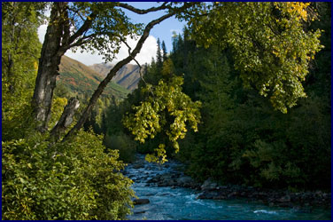
The road became increasingly narrow as it wound up into the
mountains. The scenery
was beautiful; we stopped at a viewpoint where it seemed we could
see all the way back to
Anchorage
. The valley was rich
with autumn colors; gold willow shrubs and red blueberry bushes
abounded. As we climbed
higher our surroundings became more barren, and soon we were well
above the treeline, which is only at about 3000 feet in
Alaska
.
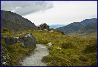
We parked at Independence Mine, a
large gold mine that dates from the early 1900s.
It was closed down in 1951, and is now a State Park.
We hiked the Gold Cord Lake Trail, an easy footpath that
traverses the rocky slopes up to the lake.
The remains of Independence Mine and its surrounding
buildings shrank in our perspective as we climbed higher along the
ridge; soon they appeared tiny in the distance.
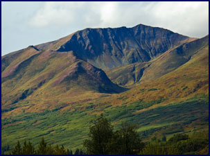
Tundra stretched before us, with a panorama of mountains on
all sides.
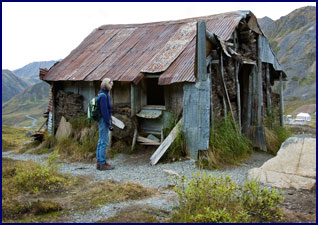
The trail took us past a long-abandoned miner�s hut, made
of logs, corrugated metal, and sod.
We stopped in for a look; it was difficult to imagine
spending the long Alaskan winter there.
We surprised an Artic ground squirrel, a small gopher-like
creature that sat up on his hindquarters and scolded us for
interrupting his solitude. We
also got several glimpses of a small rodent about the size of a
hamster, with big round ears, no tail, and very quick reflexes; we
later learned it was a pika, a distant relative of the rabbit.
Finally we reached the top of the
slope; though not a difficult hike, it was a lot farther than it had
looked from the parking lot. This
was our first experience with the Alaskan perspective of size and
distance; because the mountains are so huge and the distances so
vast, it tends to confuse your perception - we often found that
objects or hiking destinations were a lot further away than they had
first appeared.
|
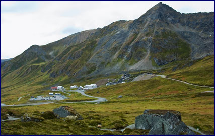
Independence Mine
|
We came to the
Gold
Cord
Lake
, a mountain tarn surrounded by rocks and huge boulders.
There was not much growing up there, only lichens, a bit of
moss, some course tufty grass and a few hardy shrubs.
The water was a deep turquoise blue color, and looked very
clear and cold. A light
misting of rain fell intermittently, but there was no wind, and
everything was very still and quiet.
From time to time we saw one or two other hikers, but
considering it was a weekend and only about 60 miles from Anchorage,
we were amazed at how uncrowded the park was � this was the big
advantage to traveling at the very tail end of the season.
We
worked our way around the edge of the lake, climbing over enormous
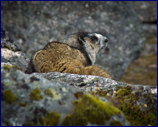
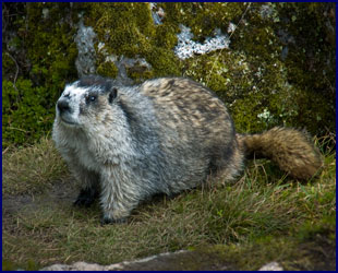
boulders. We saw
something moving up ahead and slowly crept up for a closer view - it
was a Hoary marmot, bigger than its cousin the ground hog, and much
more beautiful, with a variegated coat of brown, black and silver.
He was not particularly shy, and we were able get quite
close.
Continuing on to the far side of the lake, we sat on a
boulder and snacked on trail mix.
We figured that this had been the perfect warm-up hike for
our first day; not too strenuous, about an hour each way, just right
to break ourselves in gently. Then
someone had the bright idea (I think it was me) that instead of
going back the way we had come, we should continue around the other
side of the lake to return to the trail.
It seemed like a good idea at the time.
This route turned out to be much
steeper and more difficult than the way we had come, and much
further around than it had looked (see Alaskan Perspective above).
We found ourselves climbing up and down over steep boulder
faces and scrambling for traction with increasingly weary legs; now
we understood what the guidebooks meant when they talked about
crossing boulder fields. Soon
our thighs were burning. By
the time we made it all the way around the lake and back to the
trail, every step was an effort and our legs were like jelly.
After this little workout our leg muscles were sore for two
days, but it did do the trick regarding training; we never got sore
again for the whole trip, even though we did many far more strenuous
hikes later.
Returning to the car, we drove up Hatcher�s Pass, following
the small gravel road up a series of steep switchbacks. (Note
that its only day one and we�re already breaking the Dollar Rental
Car people�s rule about no gravel roads.)
The sky had become overcast, and it was cold and windy at the
top. The view was
impressive, with silver lakes set high on the pass, surrounded by
steep sided mountains. Paragliders
launched from a knoll near the summit; we watched them riding the
air currents down.
We
passed dozens of blueberry pickers, gathering the fruit from the
autumn-red bushes on the middle slopes of the mountains.
Not wanting to miss out on anything, we parked by the road
and tried our hand; the berries we found were small, hard and
bitter-tasting.
By then it was mid afternoon, so we
set out for
Lake
Tolsona
, our destination for the evening.
We backtracked to Palmer and then followed the
Glenn Highway east
toward Glenallen. We
stopped whenever we saw a particularly interesting spot or beautiful
view, which was often. There
were many pull-offs with scenic overlooks, often marked with a
highway sign with a little picture of a camera, indicating a good
spot for photos.
One of the best pieces of advice I was given while planning
the trip was to buy the Milepost magazine.
This is an 800 page atlas that is put out every year, which
gives an incredibly detailed description of every inch of every road
or highway in
Alaska
. It advertises itself
as �The Bible of North Country Travel,� and indeed, any
information you could possibly ask for is in the Milepost.
Roads, gas stations, restaurants, stores, scenic viewpoints,
points of interest; you name it, you can find it in the Milepost.
This is coupled with the fact that in
Alaska
all of the roads are marked with actual mile posts, and everyone
refers to these when giving any kind of directions.
For instance, if you tell someone you will be at mile 67.3 on
the
Glenn Highway
, everyone knows exactly where that is.
It is a great system, and very convenient, though I suspect
it might not work as well in states that have more than six roads .
. .
We were driving along with the
Chugach Mountains
on our right. We stopped
a few times for photos, but otherwise kept going, trying to cover
some ground. We noticed
that our little Subaru didn�t like to go too fast; it would start
to shimmy and shake every time we approached 60 mph.
We were really lucky with our
timing; there was major road construction on the
Glenn Highway
� signs said to expect 1 hour delays.
As we approached the construction area we saw a line of cars
coming toward us; we realized they had just been let through the
construction area, so our lane would be let through next.
But if we missed it, we would have to wait an hour or more!
I floored it, driving at speeds that caused our little car to
tremble like a leaf, and we just barely made it in time � we were
the very last vehicle to be let through.
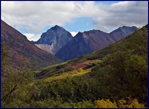
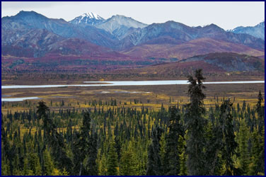
We drove through ever-changing
countryside. Much of our
route was lined with majestic mountains; the
Chugach
Range
still marched on our right. We
passed a huge icefield, which we learned from the Milepost was the
Matanuska Glacier. At
milepost 131 we could see
Mt.
Drum
, tall and snow covered on the horizon, and the Nelchina Glacier was
over our shoulder. In
these vast landscapes we would often see another car in the distance
and think that it seemed smaller than it should be; then we would
realize the scale of things and know that we were experiencing that
Alaska Perspective again.
Temporarily leaving the mountains behind, we drove through
extensive areas of gently rolling tundra dotted with Black Spruce.
Everywhere we looked there were lakes.
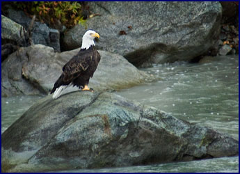
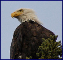
We ecstatically watched a bald eagle soaring alongside the
road, and further on we saw another, paralleling the highway.
We kept a good eye out for caribou or bears, and we stopped
at an overlook by Leila and
Tahneta
Lakes
to search for moose, but the only mammal we saw was a dead porcupine
in the road.
Curiously, we passed through
several stretches where there was a series of poles along the side
of the road, coming straight up for about 15 feet then jutting out
over the road. To
determine their purpose we consulted our trusty Milepost; we learned
that the poles were there so the snowplows could find the road in
winter.
We arrived in the town of
Tolsona
, population 24. We were
staying at the Tolsona Lake Lodge, which turned out to be not nearly
as classy as it had appeared on its website.
Our room was adequate, with a view of the lake and the
equipment shed. There
was a tiny airstrip out back. A
bristle faced dog followed us, staring at us with creepy intensity
each time we ventured out of our room.
The atmosphere in the restaurant and
bar was disappointing. The
waitress was very tired and harried looking - she had been on duty
since 7:00 a.m. and would work until the karaoke in the bar finished
at two in the morning. We
had an extremely mediocre dinner at a very high price; this turned
out to be the only over-priced place we ate at for the entire trip.
From the restaurant window, we
watched a loon on the lake in the twilight; it would dive under the
water and seem to disappear, finally coming up five minutes later,
over 200 yards away. The
waitress told us that a bear had been shot there last week because
it was breaking into the sheds, and she also said that a mother
grizzly bear with her babies had been hanging around the lodge just
the day before. She
cautioned us not to go for a walk.
Fortunately we were in the last room
on the row, so if they had Karaoke at the bar until 2:00 a.m. we
couldn�t hear it. We
slept like logs.
Day 2:
September 7
It was raining when we woke up.
We got a closer look at the loon on the lake; they are bigger
than I had realized. We
left
Tolsona
Lake
and hit the road. First
stop: we needed gas and caffeine.
In
Alaska
, towns and especially gas stations can be few and far between; it
can be hundreds of miles to the next stop, so never let the gas get
to less than half a tank. The
same could be said of the caffeine.
We had breakfast at an old roadhouse
at Caribou Creek. Several
people had told me about the great Sourdough pancakes in
Alaska
and I was eager to try them, but they had none.
However they did have nice people, a great atmosphere, and
delicious huge helpings of biscuits with sausage gravy. After
breakfast we drove on in the rain, heading east on the
Glenn Highway
.
We saw two magpies fly up in the road; a good sign - one for
sorrow, two for joy. A
bald eagle stood on a rock in the
Gakona
River
, and we photographed him from the bridge.
A pair of regal white swans floated on a lake near the road,
along with several ducks. It
looked like a good lake for moose, but none were to be seen. Gold
aspen trees mixed with the tall thin black spruce so prevalent in
the low lying areas. These
dark spruce trees were intriguing; they were thin and sparse and
somewhat stunted looking, often with oddly shaped tops that resemble
weird and twisted faces.
We crossed the braided
Gulkana
River
, with its interwoven channels criss-crossing through the gravel
bars; we imagined the huge torrent it must be during snowmelt in the
spring. We saw the
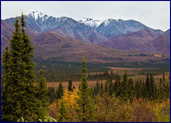
mighty peaks of
Mt.
Sanford
and
Mt.
Drum
, clothed in white, with a band of mist across their middles. We
passed by the Gakona roadhouse, said to be haunted.
Our destination was the St. Elias/Wrangell Park, which
consists of over 20,000 square miles of untracked wilderness, and is
the largest National Park in the
United States
, more than six times the size of
Yellowstone
. It has glaciers larger
than
Rhode Island
! It is also one of the
least visited National Parks in the country; most access is by small
plane, to drop off campers, hunters and backpackers who spend days
or weeks out in the wilderness.
For us less intrepid travelers, there are only two roads that
lead into the park at all;
McCarthy Road
and
Nabesna Road
. Of these two,
McCarthy Road
is much more traveled, with the historic town of
McCarthy
at the end of it, while
Nabesna Road
is pretty much nothing but wilderness.
Guess which one we took.
The rain was starting to let up by
the time we turned on to the Nabesna Road; it was cloudy, but with
occasional light patches in the sky where one could imagine the sun
to be hiding. We drove
about 20 miles down this small gravel road (yes, there we go again,
breaking the rental car rules), where we found the trailhead for the
Caribou Creek hike.
|
Nabesna Road
|
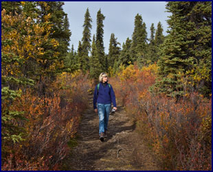
The trail started out through the woods as a four-wheeler
track of deep sand and gravel dust, difficult to walk on.
After crossing several muddy creeks our route narrowed to a
dirt path criss-crossed by roots.
We wound through the woods and came out in an open meadow,
where we had a great view of the mountains beyond.
Soon we were back in the trees again, walking beside a swift
rushing stream, uphill toward the base of the mountains.
We passed several tents and hunter�s camps. We
found moose tracks along the way (they looked nothing like the ice
cream), and plenty of moose droppings.
But sadly, no moose.
Eventually the trail petered out
along the rocky stream, and we headed back.
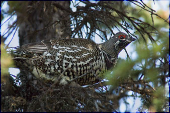
A chicken-sized bird flew across our path and up into a tree;
it was a ptarmigan, mottled in color, with its feathers just
beginning to change to white for the coming winter. It
perched in a tree next to the trail, affording us a good close look.
We had seen very little other wildlife on the Caribou Creek
Trail.
After three hours of hiking we returned to our car.
We drove back out the
Nabesna Road
, down the
Glenn Highway
, and then headed north on Highway 4, the
Richardson Highway
. We stopped for Cokes
at Posty�s Trading Post, and then made tracks to our destination
for the night.
Jineen and I like to travel without making advance
reservations, to just see where we end up each night and find
lodging on the fly. But
when I researched this trip, the people I talked to advised me to
always have reservations in advance in
Alaska
; they said that the towns are too few and far between to count on
finding lodging on short notice.
If you get to a town and there are no rooms available, it
might be 200 miles to the next one.
When we arrived in Paxson, we
understood what they meant. The
map showed Paxson to be a town located at the junction of
Richardson Highway
and the
Denali Highway
, but when we got there we realized that they were using the term
�town� loosely. Paxson
actually just consisted of a lodge, a roadhouse with a really bad
restaurant, a gas pump, and a population of 37, which includes
everyone who lives in a 30 mile radius.
In rural
Alaska
, it seems that if you have a gas pump, you automatically qualify as
a town.
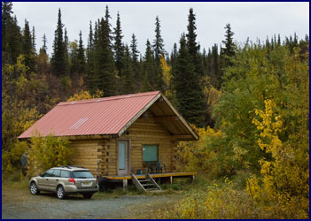
We checked in to the Denali Highway
Cabins. Our host was a
man with the unlikely name of Audubon, who just happens to be a
naturalist and a birder. (This
could not be coincidence.) We
were given a very private log cabin that sat by itself on the other
side of the highway from the main lodge.
It was very nice, with a heater, curtains, and its own
private outhouse. This
privy was quite impressive; it came complete with a flushing
mechanism (you pour a bucket of water down the hole), and had
reading material, a book called �The Outhouses of Alaska.�
Audubon (Audi for short) and his partner Jenny were very
informative about the area; they even told us about a good place to
see moose that we could visit that very evening.
But first we found a spot with a nice view on the top of the
hill, parked, and had our happy hour.
This is a tradition Jineen and I have refined on our trips -
a bottle of white wine, a little pate, some cheese and chutney on
crackers, perhaps some fresh bread or fruit; on this evening it also
served as dinner.
It was almost 7:30 when we set off on foot for
Mud
Lake
. We crossed the road,
went over a bridge, turned by the gravel quarry, and then followed a
path down through the woods. It
was starting to get dark, but the weather was still pleasant, around
50 with a nice breeze. As
we walked we saw moose tracks in the soft earth under our feet. After
about 15 minutes we came out of the trees and crossed a marshy
field; a large shallow lake stretched before us, with steep hills
rising beyond it. We
could hear the calling of loons, an eerie sound that sends shivers
down the spine.
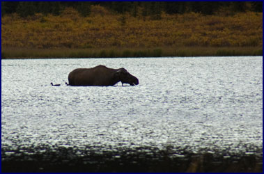
There was a large dark shape in the
water - a moose cow, silhouetted against the silvery sheen of the
lake in the fading light. She
stood out in the middle, belly deep in the water, plunging her head
under the surface to eat the aquatic plants on the lake bottom.
She would submerge her head for over a minute at a time, and
then come up munching contentedly.
Two ducks swam close beside her, feeding on her leftovers.
She appeared totally unconcerned that we were watching.
A family of swans floated by the far shore; two more arrived
and flew several times around the lake in perfect synchronization
before leaving without landing. The
loons called again. It
was incredibly peaceful - we stood there a long time watching the
dusk turn to night.
On the way back we stopped on the
bridge and gazed down at the stream, where dark red salmon were
fighting their way up the swift current.
They would cluster in groups of 5 or 6, lurking below a
riffle; then one after another they would make their move, fighting
their way upstream a dozen feet or so, where they would gather to
rest again before having another go.
It gave me a great appreciation for the arduous difficulty of
their journey.
We returned to our cabin, finished
the wine, negotiated the outhouse by flashlight, and slept snug in
our comfortable beds.
|