|
The sky had been grey and gloomy, with some light rain
falling, but as we got to Lake
Ianthe
a little sunshine was pushing through, and we were encouraged.
We had been driving for a while, and we decided it was time
for a hike. I had wanted
to get a chance to walk on the beach, and though we had taken
several small roads that went right along the shore, we hadn�t
found one yet that gave us direct access to the ocean.
It was time to remedy that.
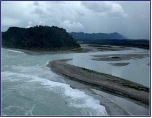
We studied the map and found a destination; the Hari Hari
Coastal Walk. We
followed this track through the bush (NZ for woods) beside a tidal
river. The ground was
very wet in places, and there were retractable fishing piers all
along the riverbank. Presently
we came to a wide lagoon; the trail skirted around its edge before
coming out on the beach. There
was a sign here with the tide charts posted.
Odd, we thought, as we noticed that high tide was still about
three hours away. We
should be back long before then. And
anyway, it was a DOC (NZ Department of Conservation) trail, open to
the public. How
important could the tide times be?
We stood by the
Tasman Sea
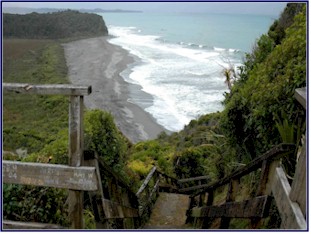
. We climbed up a long
flight of steep stairs onto a huge rock formation called Doughboy
Lookout. From the top we
could see a long way in all directions.
The wind was keen, and gulls flew below us.
The sun played fitfully in and out of the clouds, and the
roar of the surf was strong. We
gazed up and down the coastline in both directions, and back inland
where the river disappeared into the mist.
Jineen noticed a dark cloud heading our way; you could see
the rain slanting down from it as it moved straight towards us.
Uh oh, we could be in trouble!
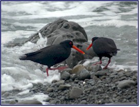
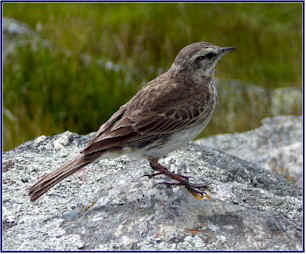
We went back down to the beach, which consisted more of
stones than sand. Gulls
wheeled in the wind overhead, while oyster-catchers scurried along
the edge of the incoming surf. We
meandered along, looking for shells, watching birds, collecting
stones. I have this bad
habit of bringing home rocks from wherever I travel � which is
fine as long as it is not done to excess, but if carried overboard
tends to make the luggage very heavy.
I found some nice pieces of greenstone,
New Zealand
jade, treasured by the Maori people.
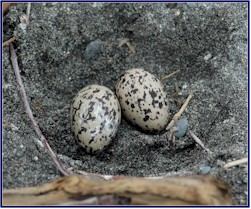
We came across a nest in the sand, with two rather large
spotted eggs, and no sign of the bird who laid them.
The eggs were in the open but very well camouflaged in the
rocks, and close enough to the high tide line to make us question
the wisdom of the nest site. Later,
looking them up in the NZ bird book, we figured that they must have
been Caspian Tern eggs; the detailed description in the book matched
perfectly.
There was not another soul in sight, and it was a lovely
peaceful way to spend the afternoon, but eventually it was time to
head back. We hiked back
along the same route, but when we got to the lagoon we were in for a
nasty shock. Sections of
our path were submerged beneath three feet of seawater!
What had been a trail was now partially a lake.
Do you think this might be why they had posted the tide
tables?
We were just barely able to scramble around the edges of the
lagoon, precariously clinging to the shrubs and undergrowth.
We managed to narrowly avoid a soaking as we negotiated the
more treacherous of the submerged areas.
It was still an hour until high tide, but if we had been just
a few minutes later we wouldn�t have been able to make it through
at all; we would have had to wait hours for the tide to recede.
By the time we made it back to the car it was beginning to
sprinkle, and as we got on the road again the rain started to pour
down hard. Once again,
we had lucked out with the weather.
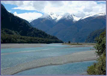
We crossed over the Whataroa
River
, with its many braided channels, and then stopped at a takeaway
place in a tiny town for a lunch of fish and chips.
We crossed the street to visit the
Maori
Art
Gallery
, and then hit the road again.
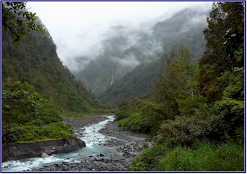
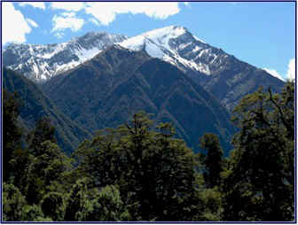
As we drove, it was beautiful along the way.
The annual rainfall in the area is very high, and the misty
brooding mountains perfectly captured the mood of the West Coast.
The roads were lined with
New Zealand
ferns, and the silhouettes of the mountains, layered in repeating
patterns, faded into the mist. We
passed secret waterfalls, spectacular in their glory but hidden from
the road unless you look from just the right angle.
The mountains here were tall enough that the crowns were
above the tree line, and indeed some were above the snowline.
But often on the higher barren mountainsides we would see a
single tree growing, one that appeared to be bravely marching
towards the summit.
There were more dead possums in this area; they seem to be
more prevalent on the West Coast.
At one point we counted 12 possums in 10 miles!
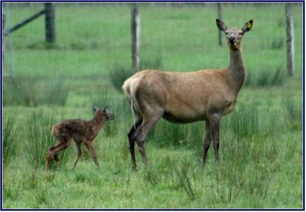
We passed a herd of
red deer
in a pasture and paused for a look.
One mother had a brand new baby fawn, just minutes old.
We could tell he had just been born; he was very wobbly on
his feet, and the doe still had the afterbirth hanging.
The mother deer became nervous when we stopped to watch, so
we moved on. We noticed
this often with the deer in the paddocks; they didn�t pay any
attention at all to the cars going by on the highway, but if you
stopped to watch them they became very wary.
They may be domesticated, but they definitely still have
their wild instincts.
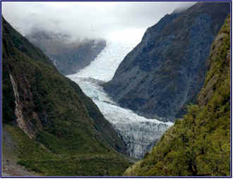
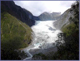
We arrived at Fox Glacier.
This is one of the few glaciers in the world that ends just a
few hundred meters above sea level.
Starting in glacier-rich snowfields high in the Southern Alps
and ending amid lush semi-tropical rainforest, it is a true example
of the incredible diversity of New Zealand.
We hiked up the Chalet Lookout Track, a really great one and
a half hour tramp that climbed up through the forest.
We came to a wide stream with a broad rocky bed; the water
was swift and cold, and long we stood, trying to summons the nerve
to cross. We met several
fellow hikers here, all with the same dilemma.
One girl attempted to cross and slipped, going butt first
into the icy water.
After a bit of exploration, we found that someone had marked
a safe crossing, a bit upstream from the main trail, with little
stacks of stones. Here
we were able carefully pick our way across, jumping from rock to
rock. An older woman
that we had seen along the trail was particularly amusing; she
seemed to be hoping her brother would fall in the water. I
was ready with the camera just in case!
After a vigorous climb, we came to a lookout platform with a
fabulous view of Fox Glacier. We
stood there, high up, and looked across the valley to the terminal
face. The ice of the
glacier had greenish blue highlights, but the snow on the tall peaks
above was pristine white. Waterfalls
high up on the mountainsides fell into the valley, seemingly silent
because we were too far away to hear their roar.
Looking closely, we could make out tiny dots on the surface
of the glacier far below us; these turned out to be climbers,
traversing the ice. This
really made us realize how immense the glacier really is.
By the time we returned from the hike it was six o�clock,
and we figured we better look for lodging.
We found a room at the first place we stopped, the Fox
Glacier Lodge. It looked
quite nice and we thought it might be pricey, but it was only $80 NZ
(about $55 USD). It
wasn�t fancy, but it was comfortable enough, with a decent shower
and a kettle to make tea. As
in most places we stayed on this trip, they asked us, �skinny or
full?� meaning did we want low-fat milk or whole milk for our tea
in the morning. The
motel rooms always had a tea kettle and a mini-fridge, and when we
checked in they would give us a small carton of milk, skinny or
full, for our morning tea.
Lodging taken care of, we drove to the main parking area for
Fox Glacier and hiked down the valley towards the terminal face.
There were great views of the glacier all along the river
valley as we approached closer and closer.
The trail crosses several rockslide areas, and a sign warned
us, �No stopping, next 300 meters.�
This struck me as quite odd; if the danger of rockslides is
so great that it�s too risky to stop on the trail, then maybe
it�s not really safe to be there at all.
But then that�s New Zealanders for you - their perception
of risk is quite different from ours.
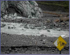
We were able to approach quite close to the bottom of the
glacier. As we got
nearer the temperature plummeted; it must have dropped at least 20
degrees in the proximity of all that ice.
It was really interesting to see the glacier so close up.
The top edge of the wall of compressed ice was jagged and
rough, and from this distance we could see that it was quite dirty;
the soil and rocks that the glacier had gathered during its journey
were clearly visible. We
could see where big chunks of the glacier had broken off and fallen
to the valley floor, exposing the clean blue ice underneath.
A swift grey river flowed out from beneath the glacier,
formed by the melting ice.
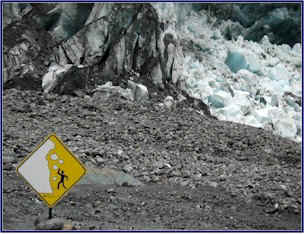
At the base of the glacier we saw a few more of
New Zealand
�s graphic warning signs. One
had a picture of a man standing near a glacier, with ice and rocks
falling on his head. Further
down was another; a man being swept away in a stream below a
glacier. Presumably
these signs were meant to discourage one from approaching too
closely!
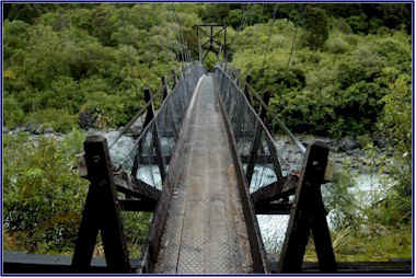
Returning to the carpark, we then took the River Walk.
We crossed over the
Fox River
on a swing bridge, a narrow strip of planking suspended by cables
high over the rushing torrent below.
These wobbly suspension bridges are often used to provide
river crossings for hikers. They
are aptly named; they sway and swing as you cross them.
There were beautiful views from both sides of the bridge; we
could see the bottom of the glacier in the distance, and the chalky
grey river that ran down from it. We
made a game of seeing if we could walk smoothly enough to keep the
bridge from swinging � the trick is to put one foot directly in
front of the other. We
perfected this technique, no hands and no sway.
But then Jineen asked, �Would you cross it like that if
there were no railings on the sides?�
No way!
We had dinner in a caf� in the town of
Fox Glacier
; the food was very good, but as we so often found in NZ, the
service was slow. When
we left the restaurant there were keas begging in the parking lot.
Keas are crow-sized alpine parrots, a muted green color with
brilliant orange and yellow under their wings, visible when they
fly. They have a
tendency to become quite tame, and to hustle handouts from
unsuspecting tourists. They
are adept at begging and stealing food, and if thwarted, they are
prone to retaliate by such methods as ripping the windshield wiper
blades and window stripping off your rental car.
As we walked through the town and back to our motel, they
were sitting high up in a tree above the parking lot.
We couldn�t see them, but we could hear their loud and
somewhat sinister-sounding cries.
We had another belated happy hour in our room.
We drank the Montana Riesling, and decided it was quite good,
definitely one of the better Rieslings we tried.
We decided to dump the rest of the St. Clair from the day
before as undrinkable; we unanimously decided it was the worst
wine we had ever had in
New Zealand
.
Day
6
We were greeted by yet another sunny day with clear blue
skies, apparently a rarity on the West Coast.
We needed to refuel, so we waited for the gas station to open
at 8:00. We had no
choice; this was the last petrol until Haast, over a hundred
kilometers away. So much
for an early start!
Soon we were on the road and heading south again.
Jineen was just pulling some things out of the grocery bags
for our breakfast when she looked up and yelled, �Stop the car!�
I slammed on the brakes in a panic, wondering what the
emergency was, and she pointed ahead to the cause of our sudden
halt. She had spotted a
freshly hit possum in the road, dead but not smashed.
A Kodak moment! We
stopped to photograph it. Now
we knew what they looked like with all the parts and fur attached.
It was interesting, but I can�t say it helped with the
ambiance of breakfast . . .
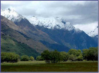
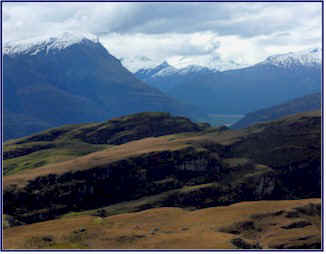
As we went further south we started to see more of the
snow-capped mountains of the Southern Alps, the impressive
�continental divide� mountain range that runs the length of the
South Island
. The contrast of
landscapes was amazing. We
stopped on a small bridge, where to the right we could see the
turquoise blue waters of the
Tasman Sea
breaking against the rocky shore, with palm trees and tropical
vegetation, while to the left towered tall forest-covered mountains,
their peaks capped in white. The
amazing diversity of
New Zealand
was one of the things we loved most about it; in a few hours time
you could go from sub-tropical coastline to snowy peaks and
glaciers, with every type of landscape you could imagine in between.
We stood at Knight�s Point, an overlook high on a cliff,
and gazed down along the shoreline.
The blue water seemed on fire in the bright sunshine.
Gulls cried and wheeled below us, and we watched the lines of
breakers rolling in to the beach.
There was a sign that informed us that if we headed west we
would come to
Australia
in 1700 kilometers, but if we went south there was no land between
us and
Antarctica
.
Early on, the road was empty.
It was just us, an occasional car or camper-van, and the dead
possums. Jineen started
counting them when we left Fox Glacier; it was a contest to see
which there were more of, vehicles encountered on the road or dead
possums. For a while it
was a close race, with the possums winning, but after a while
traffic picked up some and the cars took the lead.
So the possums were the losers, in more ways than one!
We turned inland, and started upwards towards the
Haast
Pass.
The road climbed and
dived as it made its way through the mountains along the course of
the
Haast
River
. There were hairpin
curves overlooking sheer drops, and as is typical in NZ, no
guardrails. The scenery
was spectacular, with snowcapped mountains at every turn.
Waterfalls cascaded down the steep sides of the mountains,
and the roadside was lines with ferns.
We stopped at a scenic spot called Prospector Flats, with a
view of
Mt.
Cuttance
. We decided to switch
drivers for a while. I
have spent a fair amount of time in
England
and
Ireland
, so I am quite used to driving on the left; our usual mode of
operations is that I drive and Jineen reads the map and navigates.
But in this instance Jineen took over driving for a while to
give me a break. She did
a great job, but she wasn�t really that comfortable driving on the
left, and I wasn�t that comfortable navigating, so soon we
switched back and kept to our respective roles for the rest of the
trip.
We came to the Gates of Haast, where we crossed the bridge
and stopped at an overlook to watch the swift descent of the
turquoise water as it rushed down over the boulders.
Then we continued climbing towards the pass.
Many of the peaks were wearing a dusting of fresh snow.
We wound through the mountains, crossing the many-channeled
green rivers that ran down from the glaciers and snowfields near the
peaks. We kept an eye
out for hidden waterfalls and searched for glaciers;
Mt.
Aspiring
Park
has more than 50 of them.
Once we were through
Haast
Pass
, the climate changed dramatically.
We had crossed the
New Zealand
continental divide, and were now on the eastern side, though still
among the
Southern Alps
. Immediately the
countryside was much drier, and by comparison, a little
barren-looking. The
lands was open, the views long, and the mountains were no longer
covered in bush. We were
back to sheep pastures and farms, but with the spectacular
Southern Alps
alongside them. The road
was lined with yellow lupins and pink wild roses.
The embankments beside the road looked like colorful rock
gardens.
This part of the countryside turned out to be possum alley;
by the end of the day the count was 37.
But I wouldn�t want you to think we were obsessed with
roadkill or anything!
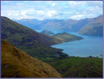
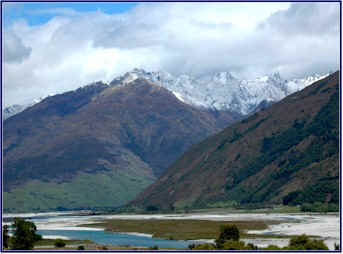
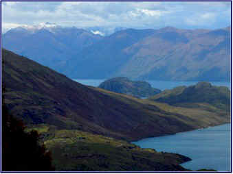
We came to
Lake
Wanaka
, where the road skirted its eastern edge before crossing over a
narrow spit of land to
Lake
Hawea
, stunning with its turquoise waters and mountain backdrop.
We followed its western shore for a while, before crossing
back over to Wanaka. The
clouds were starting to move in, and we passed through a few showers
amid patches of sunshine. But
we could see some serious rainclouds moving our way.
We had come back into cell phone range after having had no
service on the west coast, so we were able to get our messages and
call home. Renting a
cell phone had seemed like a good idea, and it supposedly would
receive international calls from home at no charge; but the catch
was that we were rarely in an area where we got service.
We turned up
Mt.
Aspiring
road, on the western side of
Lake
Wanaka
. We had driven through
this area on our previous trip, but I had forgotten how beautiful it
is. The road was lined
with flowers, and incredible vistas waited around every corner.
We stopped repeatedly for photo ops. The
rain ended, and the sun peeped out amid patches of blue.
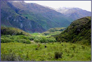
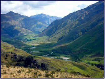
We came to the Diamond Lake Conservation Area, where we
planned to hike up
Rocky
Mountain
. We started from the
small carpark at the trailhead, and set out through cattle and sheep
pastures. The trail
sloped gently upwards until we reached
Diamond
Lake
. We saw a variety of
birds on the way up, as the path wound through thickets and groves
of trees; Jineen is really good at identifying them.
The bird songs were lovely; we stopped and closed our eyes to
just listen. The only
sounds we could hear were the songs of a dozen different birds, the
breeze in the trees, the occasional drone of a bee or call of a
sheep, and the faint distant roar of the tall thin waterfall on the
mountainside opposite us.
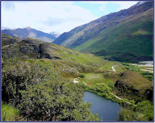
The track climbed to a lookout point above the lake, and then
continued on up the side of the mountain.
We followed it up through the forest for a while, and then
out onto the open mountainside, an area of rocks, shrubs, and sheep.
We climbed higher and higher, trudging back and forth up the
switchbacks, at times climbing steeply up the cliff face, with the
views changing and improving at every turn.
We left the sheep behind as we neared the top, and the ground
became steeper and rockier, and the climb more strenuous.
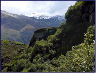
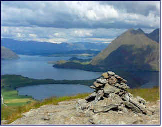
Finally we came to the very top of
Rocky
Mountain
. It was fabulous!
A small tower of stacked stones marked the summit, and a
broad flat rock outcropping offered seating.
There were awesome views 360 degrees around us.
To the east we looked down over the blue-green waters and
undulating shoreline of
Lake
Wanaka
. To the south we could
see down a long river valley, and to the west a ridge of high
mountains loomed close above us.
To the north, amid a range of high snow-clad peaks, we could
make out
Mt.
Aspiring
in the distance, its head shrouded in clouds.
This is one of the most spectacular mountains in NZ.
It is 3033 meters high, and its Maori name means �
Glistening
Peak
.� When the sun hits
the white snowfields near the summit it does indeed glisten, but you
rarely see the very top of the peak because of the clouds that hover
there.
We spent quite a while on the top of
Rocky
Mountain
. The sun was out and
the weather had again turned lovely (our customary good timing), and
it was incredibly peaceful. This
was one of the most beautiful spots we had seen, and it had a
magical feeling about it. We
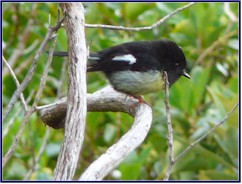
sat on the rock outcropping and shared our trail mix with a little
brown bird that joined us (later identified from the bird book as a
NZ pippet). While we
were there a couple from
Connemara
,
Ireland
joined us on the top, they were the only other people we had seen on
the mountain.
The descent was much easier, though going down is hard on
different leg muscles. We
noticed that our legs were not nearly as tired and rubbery as when
we hiked
Mt.
Robert
at Nelson�s Lakes; was this hike that much easier, or were we
getting fitter? Perhaps
a little of both!
We parked by the side of
Lake
Wanaka
for happy hour that evening. We
turned down �
Ruby Island Road
,� lined with yellow lupins and wild rosebushes.
In the late evening light the bunnies came out to play; we
watched them as we finished the Montana Riesling.
Once again we had no problem finding lodging on short notice;
we procured a really nice room for a very reasonable rate at the Mt.
Aspiring Lodge in Wanaka. We
went to an Irish Pub for dinner, where I had the best fish and chips
I have tasted in 10 years.
The pub owner came over to our table and chatted with us, and
the conversation took its usual turn.
People in
New Zealand
tend to be very friendly and gregarious, and they would generally
start a conversation by asking where we were from.
We quickly found out that as soon as we told them we were
from the
U.S.
, or especially that we were from
Virginia
(being near
Washington
,
DC
), this would usually lead to either dead silence or to the voicing
of heated political opinions. As
it often brought the conversation to a grinding halt, we decided
that from then on we would tell anyone who asked that we were
Canadian. We cooked up
an elaborate story about our home near
Toronto
, so that we could be convincing, eh?
After dinner we had one last glass of the Montana Riesling by
the shore of
Lake
Wanaka
� it was after ten o�clock and still not yet fully dark.
It had been a great day and a spectacular hike; and neither
Jineen nor I were feeling any pain!
~ continued ~
|