|
Day
7
We awoke to my alarm clock for the first time on the trip.
It had been set for 6:45 every morning, but this was the
first time we hadn�t been up and dressed before it went off.
Not that we are such early risers, but we still weren�t
totally adjusted to NZ time; at home it was lunchtime, but
yesterday. We were on
the road by 7:30 � we didn�t want to waste any of our vacation
time sleeping in.
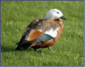
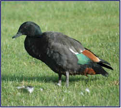
We stopped in Wanaka to photograph a pair of Paradise
Shelducks in the park. They
tend to be very shy, and I had been trying to get a close-up shot of
some all week, but this pair appeared unafraid and I was able to
easily get within camera range.
We headed down the
Cardrona Road
towards Queenstown. The
road was lined with yellow broom in full bloom, and with yellow,
pink and purple lupins. These
flowers gave a bright splash of color and beauty to the
Cardrona
Valley
, which is otherwise very dry and barren.
It is amazing the difference a few miles makes; the Wanaka
area was green and beautiful, and the
Cardrona
Valley
, just a couple of kilometers south, was almost desert-like.
We had driven this road in 2004, and we were surprised this
time to see that �bra fence� was no longer there; we later
learned that the highway department had removed it because it was
causing traffic tie-ups. (Bra
fence was a stretch along the
Cardrona Road
where the women of NZ inexplicably hung their bras on the fence;
there were thousands of them. Jineen
made a contribution in 2004!)
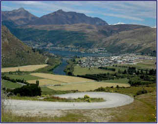
We reached the end of the valley, and stopped at a scenic
overlook where we could look down over Arrowtown.
Ahead of us the countryside was once again fairly green, and
quite lovely. We were
dismayed to find that someone had thrown a bunch of beer bottles out
on the side of the road; this is something you don�t see too often
in NZ. Jineen picked
them up and we took them to the nearest rubbish bin.
We negotiated the ridiculous road down to Arrowtown �
unbelievably tight hairpin turns down the face of the mountain, no
guard rails of course. (We
had actually been surprised to see a few new looking guardrails on
the upper part of the road before the descent, but there were none
here on the hairpin curves where they were really needed!)
There had been fewer dead possums on the road today (only 13
so far), but to Jineen�s dismay this seemed to be Suicide Hill for
bunnies; we saw an abundant number that had been hit.
It was hard to believe that anyone could negotiate this
treacherous piece of highway fast enough to run over anything,
but apparently they did; our roadkill count on this stretch also
included a ferret, a hedgehog, and a dead fish!
Go figure.
We passed Queenstown, often called �the adventure capital
of the world�. We
had visited it on our 2004 trip (and bungee jumped!), so we didn�t
stop. Just south of
Queenstown, we passed a very steep rugged-looking mountain range on
our left called �The Remarkables.�
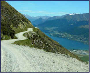
We decided to drive up the unsealed road to the Remarkables
Ski Field at the top.
We turned up the small lane, and before long we came to a
gateway with a sign that read, �This road is not maintained from November to April.
It becomes very rutted and rough.
Please use Extreme Caution.
Drive at your own Risk!�
�But after all,� we thought, �it�s the
road to the ski field, and it�s open to the public.
How risky can it be?�
We headed up the road, which wound back and forth across the
side of the mountain. The
views were �remarkable.� Ha,
ha, pardon the pun. But
at least I have a new superlative to describe the scenery.
We could look down over the whole town of
Queenstown
. We stopped to watch a
hang glider soaring; he had launched from the summit.
He road the air current down in spirals, and finally landed
in the river valley below us.
We went up and up. The
gravel road was narrow, steep, and very, very twisty.
The higher we climbed the more rutted and rough it became.
The turns on the switchbacks were so tight and steep that we
couldn�t see the road above us; we felt like the car was just
pointing into space - all we could see was sky.
I hugged the uphill side of the turns, regardless of which
side of the road I was supposed to be on (Jineen coined a new term;
road hugging). The sheer
drop-off beside us was hundreds of feet, and more like thousands as
we got nearer the top. You
guessed it, no guardrails.
By the time we got near the summit we were literally clinging
to the side of the mountain, barely crawling along.
Snails move faster. I
am sure the scenery was fabulous, but I didn�t enjoy it. In
fact, I�m not sure I even saw it!
I felt kind of sick, and Jineen looked a bit green too.
I knew that if we ever made it to the top alive, my
white-knuckled fingers would have to be pried off of the steering
wheel. �How risky
could it be?� indeed!
Eventually, against all odds, we came to the top.
There was a good sized parking lot and a lodge, but we were
surprised to see that the ski area itself was really small, with
just two short lifts, and very short ski runs.
It was amazing to us that people would actually negotiate
that outrageous road to go up there to ski such a small area.
We considered ourselves lucky to be alive after driving it in
the summer; we could only imagine what it would be like when covered
in snow!
We met a lone hiker in the parking lot, with a pack and ice
crampons. He told us
that there was a track up from the lodge that went along the
ridgeline, and not being eager to get back in the car immediately,
we decided to go for a walk.
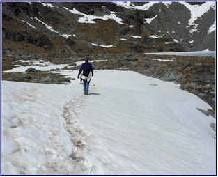
We went past the ski lodge and followed a tiny path that
wound up among the rocks and across the tundra. We
climbed up the rocky trail, crossing snowfields as we got higher.
The sun was shining brightly; it had been a little hazy down
in the valley, but here on the mountaintop the crystal clear sky was
an amazing deep shade of blue. We
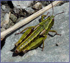
were at a high elevation (2324 meters), and about the only living
things we saw were mosses, lichens, a few tussocks of stiff tough
grass, and grasshoppers. We
picked up some purple stones to add to our collection.
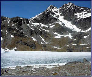
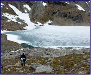
Presently we reached
Lake
Alta
, a small ice-covered lake nestled in a bowl among the peaks.
We came to an icy stream and drank from it before crossing;
this may have been the purest water I have ever tasted.
We saw a group of climbers in the distance, working their way
up a steep channel of ice and snow.
Practicing for Everest, no doubt!
We continued up towards the ridgeline.
We clambered over the rocks and across snowfields, and the
path got smaller and harder to follow as we climbed higher.
We tried to step only on the rocks, to avoid damaging the
moss underfoot. We sat
on a high rock outcropping and looked down on the frozen lake.
The rest of the world seemed remote, distant.
The air was cold, but the sun was warm on our faces.
It was very peaceful.
Eventually we returned to the parking lot, where we had to
face the prospect of the drive back down.
I offered to let Jineen drive, but she declined.
We headed down that crazy treacherous road, hoping the brake
pads were new. It was
slightly less terrifying on the way down; but I kept the car in
first gear the whole way. We
stopped for a few �photo moments� at a spot where we could look
over Queenstown and
Lake
Wakatipu
. A lamb was sitting on
the brink of the cliff, panting in the warm sunshine.
It was 13 kilometers (about 8 miles) from top to bottom, and
it took us thirty minutes to drive it.
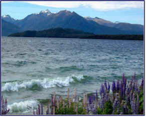
We continued south along
Lake
Wakatipu
, with the mountains on either side of us.
We passed the Kingston Flyer, an old style train converted to
use for scenic rides, going from
Kingston
to Fairlight. We passed
through green farm country, thick with cattle and sheep.
We went by dozens of huge stations, with large mobs of sheep,
the most we had seen on the trip so far.
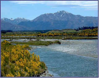
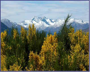
There were great areas of flowering broom and lupins, lining
the road, lining the river beds, and at times lining the lower sides
of the mountains with yellow. We
stopped by a bridge over the
Matauna
River
; the whole riverbed was bordered with the brilliant flowers.
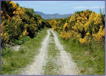
We noticed a small gravel road by the bridge, and thinking it
might lead down to the river, we followed it.
The lane was totally lined in yellow broom, and it went quite
a ways along the valley before turning towards the watercourse.
Immediately the lane forded two small channels of the river.
The first one was OK, but the second had a good sized
drop-off, and we bottomed out. Our
wheels spun madly for several long moments, and we barely made it up
the opposite bank. Whew!
Time to turn around. �Damn,�
we thought, �now we have to do it again!�
I went at a medium speed and put the car at that deep river
crossing for a second time. For
a moment it seemed like we would get mired down, but our valiant
little Honda dug in and got us across the channel.
Good car! Thank
goodness for 4WD. This
was definitely the �Road Less Traveled.�
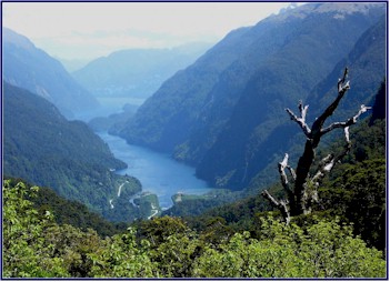
We arrived at
Lake
Manapouri
in the late afternoon. Looking
for lodging, we found a room right away, with a lovely view
overlooking the lake. It
was very quiet, and the town seemed to be empty.
Once again, we were amazed at how uncrowded everything was;
just before Christmas was definitely a perfect time to visit NZ.
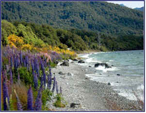
We walked along
Frasier
Beach
, on the
shore
of
Lake
Manapouri. Lupins and
broom bloomed all along the water.
The wind was strong enough to cause a bit of surf on the
lake, with small breakers rolling on to the beach.
We collected stones, washed smooth by the water; I found
several beautiful pale green ones that I carried in my pocket for
the rest of the trip.
Jineen found a sinewy piece of driftwood, about three feet
long, iron hard, and twisted into a serpent-like shape.
It appeared to have a face, and indeed Jineen also attributed
it with a personality. She
named it Manny (short for Manapouri), and neither of us being one to
pass up an opportunity for a spot of anthropomorphizing, we soon
realized that Manny had his heart set on traveling with us.
We walked along the
Old Coach Road
, a path that went along the lakefront and then turned up along the
Waiau
River
. It was a pleasant
trail among the trees beside the waterfront.
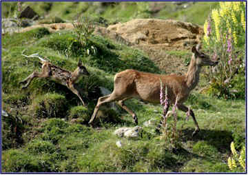
We passed a paddock of
red deer
, where several of the does had young fawns.
We saw many birds in the woods and thickets.
We disturbed a pair of fantails, and watched their ridiculous
antics as they tried to lure us away; they must have had a nest
nearby. We saw about
half a dozen plovers chasing a hawk across the sky.
We drove up a gravel road through the forest and found a
lovely spot for happy hour, right by the edge of the lake, with
amazing views of the mountains across the water.
It was very beautiful and very private.
We opened the Esk Valley Hawke�s Bay chardonnay; it was
excellent, we gave it three and a half stars.
Day
8
Again we woke up to sunshine and good weather.
We went down to the tiny town of
Lake
Manapouri
and had an excellent breakfast at Caf� 23, an old wooden church
converted into a small caf�. The
seats were old original wooden pews, and the arched windows reminded
you of the former role of the building.
The owner was a friendly woman who made delicious
sandwiches, pastries and pies. She
chatted with us while we ate breakfast and asked us where we were
from. Jineen and I
looked at each other and giggled; �
Canada
� and �
Toronto
� immediately came to our minds.
But despite our planned deception, neither of us could quite
bring ourselves to lie about our origins.
�
Virginia
,� we admitted.
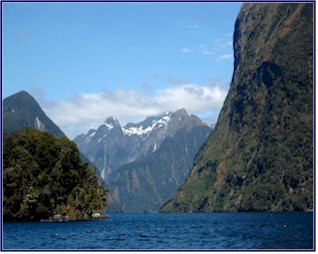
We took the �Fiordland Explorers� Doubtful Sound cruise.
We had wanted to get a chance to explore the sounds of the
south-western part of NZ, known as �Fiordland,� but had been
reluctant to sign up for a cruise for fear of it being crowded and
overly �touristy.� We
were delighted to find this company that operated tours with smaller
groups.
Our trip started with a 45 minute boat ride across
Lake
Manapouri
. Mike, our boat driver
and tour guide (who incidentally looked quite a bit like Lance
Armstrong), gave us interesting and funny commentary along the way.
The boat was enclosed and warm inside but we wanted to be
outside and feel the fresh air, so we went out on the back platform.
Well, the air was fresh, all right.
In fact, it was downright freezing!
The wind was very strong as we flew across the lake, and we
hunkered down behind the cabin for shelter.
But the scenery was beautiful!
We came to shore on the West Arm of the lake, boarded a bus,
and toured the hydro power station.
Mike took us down a two-kilometer tunnel, just barely wide
enough for our bus, and we took a brief tour of the facility.
It was all underground, and we were able to view the working
machinery through big glass windows.
Signs on the wall gave us information:
The station had been constructed from 1963 through 1971,
built by rough men who lived on a big boat harbored there in the
lake. They mainly worked
in complete darkness, tunneling and blasting; it was a very hard
life. Sixteen men were
killed during the construction, mostly in blasting accidents.
They were memorialized by a plaque on the wall that listed
their names, and bore the inscription:
�God give them quiet rest.�
Mike then drove us the 20 kilometers over
Wilmot
Pass
, on a small winding unsealed road.
It wound up over the mountains, past waterfalls, and
eventually down to Doubtful Sound.
Mike told us that
Wilmot
Pass
was discovered in the 1880s by accident, when a man disappeared in
the area and his friends went out searching for him.
They never found the man, but they did map the route for the
pass. When the road was
built, it ended up being the most expensive (per square foot) ever
built in NZ. It goes
only from
Lake
Manapouri
to Doubtful Sound, not accessed by any other roads, and can only be
reached by boat.
We waited beside the water and fought off sandflies while
Mike got the second boat, which took us through the sound.
The scenery was unique and beautiful.
The mountains were very steep and sheer sided, with their
vertical faces continuing down into the water, so the boat was able
to approach very close to the walls.
Tannin from the forest, leached from the trees, runs down the
streams and into the water of the sound, blocking out the sun and
making the water appear black.
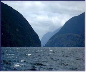
It was quite nice and sunny, but Mike told us that the
weather near the pass often has nothing to do with the weather
further out on the sound. We
learned that the West Arm of
Lake
Manapouri gets about three meters of rain annually, but parts of
Doubtful Sound get 7 to 9 meters.
That�s up to 30 feet of rain!
Sure enough, when we got further out in the sound it was
cloudy and spitting with rain.
Jineen and I rode out on the front of the boat, and it was
freezing. The wind was
whipping like crazy; Mike explained that it usually picked up like
that on sunny days. It
was great to sit on the front of the boat as it raced across the
water with the wind strong in our faces - but we had to go inside to
warm up now and then.
We traveled a long distance up the sound, exploring some of
the smaller channels that branched off of the main waterway.
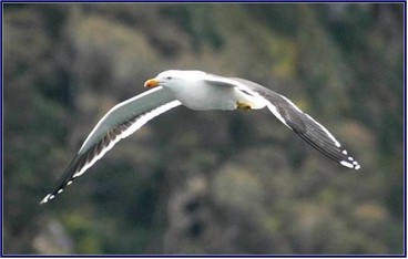
We looked for penguins on the islands, but they had all left
for the season. Seagulls
flew close by us. On the
open water the wind continued to blow really strongly, but in the
more sheltered coves it was quiet and serene, and the obsidian water
reflected every surface.
Mike brought the boat right up close to several small high
waterfalls. We gazed
straight up as the water cascaded down the cliff. It
looked almost like snow as it fell toward us, but it disappeared
into mist as the wind caught the droplets and dispersed them.
At one larger falls, the boat was so close to the cliff face
that we could hold out a cup and fill it with water.
When we returned to our launching point near
Wilmot
Pass
, we left the clouds behind us and were once again in sunshine.
We got back on the bus and headed for
Lake
Manapouri
. As we started up the
steep road, Mike pointed out a small area beside the river, just a
couple of acres, and told us how the DOC had sent a trapper in to
reduce the possum population. In
just that one small area, the trapper had caught 350 possums on the
first night, and over 800 in the first week!
This really shows how rampant their population has become.
Returning to
Lake
Manapouri
we boarded the original boat, again sitting out on the platform at
the rear as we headed back across the lake.
But Mike drove much faster on the way home, and the spray
started whipping up; soon we were soaking wet and scrambling to get
inside the cabin.
Returning to town, we stopped back at the Caf� 23 and bought
sandwiches and supplies for later.
We headed north, up past Te Anau, where we walked the track
to
Lake
Mistletoe
. It was an easy path
through the beech trees, lined with the ubiquitous broom bushes.
The forest floor was covered in thick soft moss, springy
underfoot like a mattress. When
we looked up through the tall trees, the tops of them were swaying
wildly in the strong wind. Ducks
and geese swam on the blue lake, and evergreen trees and mountains
provided a spectacular backdrop.
Following our usual custom of finding a beautiful and
secluded spot, we had happy hour and dinner by the
shore
of
Lake Te Anau
. The wind was still
very strong, but we were cozy inside the car.
The sandwiches from the Caf� 23 were excellent; wraps of
venison, lamb, and smoked salmon.
We finished off the last of the Hawke�s Bay chardonnay
(excellent), and opened the Pegasus Bay Riesling � we had liked
the label, but the wine was below average � we gave it only one
star.
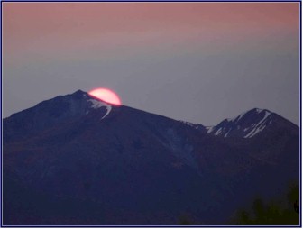
We sat and watched the sunset.
The large red disk of the sun hovered above the mountains,
before sliding down behind a peak and disappearing with surprising
speed.
Day
9
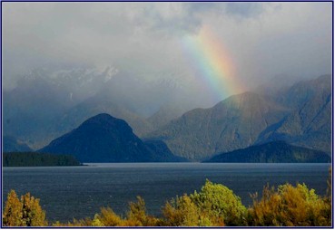
It had rained most of the night; we listened to it beating
down on the roof, thinking that it didn�t bode well.
But in the morning when I looked out the front window, I was
greeted with a beautiful rainbow arching down into
Lake
Manapouri
. I hurriedly pulled on
my jeans over my pajamas and went rushing out with my camera.
We went to Caf� 23 again, where we breakfasted on venison
sandwiches. We visited
the petrol station, and then set off south; having spent most of the
previous day on the boat, we were looking for a good hike.
We followed the Southern Scenic Highway, one of the least
traveled routes in NZ. About
the only other vehicle we saw was a psychedelically painted
hippie-type mini-van. The
scenery was beautiful, with broom-lined rivers flowing down from the
mountains.
We turned up the
Borland Road
, a small lane that took us back into the
Fiordland
Park
. Before long it turned
to gravel and passed through a sheep gate; a bearded man held it
open for us. There was a
notice posted that said, �Road Open,� we figured that was a good
sign.
The unsealed one-lane road was narrow and winding.
It roughly followed the huge power lines that came from the
power station on the West Arm of Lake Manapouri.
It wound along the sides of cliffs, often with sheer
drop-offs to the river far below.
The road was steep and much eroded, and in many areas
flooding had washed parts of it away.
We came to what we decided was a �NZ guard rail�; two
sticks set upright in the mud where the edge of the road had
crumbled away above a huge drop-off, with a strand of blue tape tied
between them.
We noticed a lot of rock slides above us, and we wondered how
often they blocked the road. Then
we rounded a corner and found the answer to that question.
On the right the road was eroded, crumbling away at the edge
to a sheer drop-off of hundreds of feet, and on the left it was
blocked by a pile of rocks that had fallen from the cliff.
We were barely able to squeeze through, holding our breaths
as the left wheels climbed the rock pile and the car tipped
alarmingly towards the abyss. And
we weren�t even to the part yet that was marked on the map as 4WD
only.
We finally reached the viewpoint at Borland Saddle, where we
had planned to hike the
Mt.
Burns
track, but when we got there it was very cold and windy, and
starting to rain. We
were deep into Fiordland, where it seems to rain most of the time.
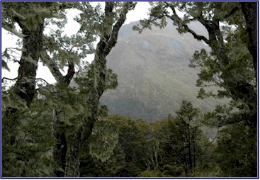
The forest up on this high mountain pass was amazing; the
trees were draped in long flowing strands of moss, and it looked
like a fairyland. But
the clouds obscured the views and the rain was pelting down harder,
so we decided to forego the hike in such miserable conditions.
We set off back down the road to see if the weather was
better further on; sure enough once we left the
Fiordland
Park
and returned to the Southern Scenic Highway it was a lovely day with
sunshine and just occasional showers.
Driving south, we went through rolling farmland.
There were hardly any cars on the road, and the scenery was
beautiful. The landscape
seemed to consist mostly of sheep stations; as far as we could see
the hillsides were dotted with sheep.
There were cattle and deer in the fields also, but no horses.
We saw two lambs asleep on top of a hayroll.
Coming to the town of
Clifden
(which according to our guide book had several interesting
attractions), we planned to go to the Department of Conservation
Information Center and get the details on things to see and do in
the area. The DOC has
welcome centers or information centers in each town, but usually we
seemed to either get on the road before they were open or roll into
town long after they were closed, so we rarely got to take advantage
of this excellent resource. But
for once we would be arriving in town mid-day so we could visit the
info center. The only
problem was we couldn�t find the Clifden DOC info center.
In fact, we couldn�t find Clifden.
Because it wasn�t there!
It showed up on our map as a town, but all there was to it
was a couple of houses and a sign.
This could be a problem, as Clifden was where we had planned
to find lodging that night . . .
We made a quick stop at the
Clifden
Suspension Bridge
, built in 1902. I
thought the most interesting thing about it was the plaque beside
the bridge, telling about a young man named Joseph Carthwaite.
He drowned while trying to deliver the mail about the time
the bridge was built, and his body was found months later in a place
now known as Mailboy�s Cave. Some
say his horse was found drowned also, others say the horse finished
the mail run alone.
~ continued ~
|