Day 6 - July 26
It was raining hard when we woke up. We lingered over breakfast and talked with the lady who ran the B&B, learning the local lore. One of the more interesting things about conversing with people in the Highlands is their accents; some of them have such a strong Scottish burr that it is difficult to understand a word they say, and they use many idioms that seem unusual to us. For instance, they always say �wee� instead of little; for a bit of local flavor I shall endeavor to do the same for the rest of this story.
We drove north, past Loch Ewe, which opens to the sea; it was used by the Royal Navy as a submarine base during World War II. We also got a view of Gruinard Island, which was used during WWII for biological warfare research to test anthrax. Supposedly it was decontaminated in the 1990s, but the locals still do not consider it safe to visit.
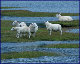
We came to Dundonnel, where our B&B lady had told us that wild goats can sometimes be seen near town. We couldn�t find any goats, but we did see something even better � swimming sheep. Several small groups of sheep were grazing on a flat area at the end of the loch, and as the tide came in they were surrounded by water and had to swim to higher ground. You don�t see that every day! (Well, maybe you do, if you live in Dundonnel . . .)
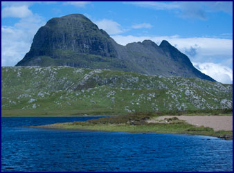
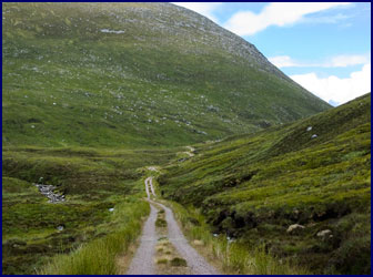
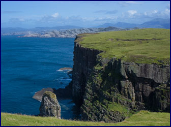
We passed through Ullapool, a beautiful town on Loch Broom. The loch, which opens into the Annat Bay, was full of sail boats. We stopped by the visitor center for some hiking info, and headed for Stac Pollaidh, a very distinctive mountain that is popular with climbers. But when we got there, the weather had turned very stormy, and though the rain had stopped, the wind was so strong we feared it would blow us off the mountain, so we passed it by.
|
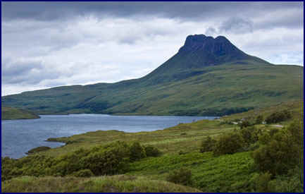
Stac Pollaidh on a
stormy day.
|
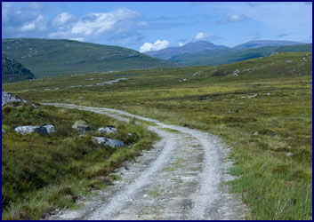
We went on to the Falls of Kirkaig, and walked the four kilometer trail to the falls in intermittent rain. We passed quite a few other hikers coming back down the trail, but we had timed it just right, and by the time we got to the falls no one else was there. The swift stream thundered impressively down over a sheer sixty foot drop, forming a swirling pool at the bottom. The path was lined with trees and heather, and we climbed down over the treacherous rocks to the base of the falls, the roar of the water loud in our ears.
|
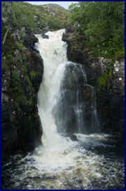
The heather path
to the Falls of Kirkaig.
|
Rather than turning back, we decided to follow the small unmarked path that continued upstream. It wound among the rocky hills, heading toward several tall peaks in the distance. It was extremely remote and private, and we were miles from the nearest road. Eventually we came out to the side of a loch, and followed its rocky shore until we came to a wee beach, with a view of the towering Stac Pollaidh in the background. There was a campsite by the beach, and we sat on the rocks and ate trail mix and cookies. Before long a wee boat came into view - a man and a boy were returning to the camp after fishing; they were very friendly, and did not seem particularly dismayed to find visitors in their campsite. We hiked back in the rain, returning to the car four hours after we had left it, quite soaked but happy.
We went into Lochinver for a seafood dinner at a nice pub that was right by the water. We had heard you could sometimes see seals down at the pier in town, so after dinner we went in search of them - but all we found were midges. We stayed at a nice farmhouse B&B called the Ardmore House. The B&B lady put our sopping coats in her �drying closet,� and I dried my boots with the hairdryer. Our beds were horribly uncomfortable, and Jineen�s made horrible loud creaking noises each time she moved, so we didn�t sleep the best.
Day 7 - July 27
My birthday! We woke up to a �fine soft day,� which is a British way of saying it was raining cats and dogs. We drove past Loch
Assynt; it looked like it would be incredibly beautiful on a nice day, but we could barely see it for the rain. There were many small islands with trees on them � it would be a great place to explore in a boat.
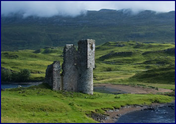
Continuing on along the shore of Loch Assynt, we came to Ardvreck Castle, sited on a wee peninsula. The rain let up, and the sun obliged by coming out for us as we explored the castle remains.
|
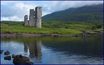
Ardvreck Castle
|
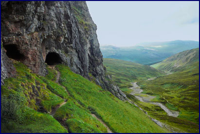
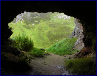
We went on to Inchnadamph, where we hiked the trail to Bones Caves. We followed a rocky riverbed up through the limestone valley; the flowing stream was small, but we could see where it could become a raging torrent in wet weather. Underground springs bubbled out of the ground to join the stream.
After a couple of miles, we climbed up to the base of a large cliff, where we found the caves. There were four or five openings into the rock wall; the mouths of dark caves, connected by narrow tunnels. It was then that we realized we had left our torches in the car; how stupid to bring flashlights all the way from home and then not have them in our packs when we need them!
|
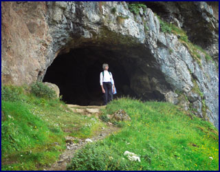
The Bones Caves
|
The Bones Caves had gotten their name because they are a major archeological site; the fossilized bones of bears, reindeer and wolves that once roamed Britain have been found there. We explored the caves as well as we could in our torchless state, thinking of the predators who had taken shelter there in primeval times. Standing in the mouth of the cave, we looked down over the valley before us, the sky in sun and shadows, and rain showers slanting across the valley between occasional shafts of sunlight.
In the afternoon we visited Handa Island. Back in the early 1800s this island had a population of 65, but the potato famine of 1848 forced the inhabitants to emigrate elsewhere. Now the island, a little over one square mile in size, is a bird sanctuary, home to over 200,000 seabirds.
The passenger ferry to the island was a wee boat that left from the town of Scourie, crossing the Sound of Handa and landing on a sandy beach. We had a briefing at the ranger station, and then set out on a three hour circuit around the island. The path climbed steadily across the open grassy moor as we headed to the north side of the island, crossing the wettest areas on small boardwalks. We passed several small lochs, but there were no trees. A strong breeze moved through the grass and heather.
|
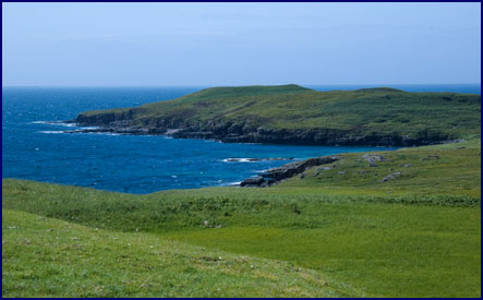
Handa Island
|
The birds were amazing. Graceful kittiwakes soared on the wind, hanging almost motionless as they rode the air currents. Great Skuas circled a shallow lake, grouse hid in the tall grass, and gulls and terns flew along the shoreline.
At the north end of the island we stood at the top of 400 foot cliffs, looking down at the crashing waves far below. Just off the shore stood a huge sea stack; this freestanding pillar of layered rock is the nesting ground for tens of thousands of guillemots. These largish birds have white fronts and black backs, somewhat resembling slender penguins, though they are good fliers. It is estimated that there are 120,000 pairs of guillemots breeding on Handa Island, and most of them seemed to be standing along the narrow ledges on this one large sea stack. They were all talking at once; a cacophonic roar filled the air.
|
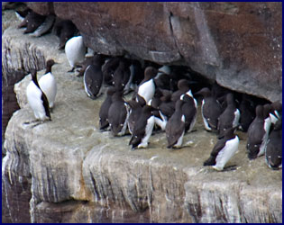
Guillemots on the sea
stack at Handa Island. |
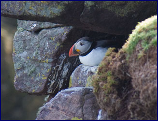
There were other birds residing on the cliffs as well; gulls, shags and razorbills nest there, and twice we saw a single fulmar baby, fluffy and newly hatched but already the size of a small gull, sitting precariously on a narrow indention in the cliff wall.
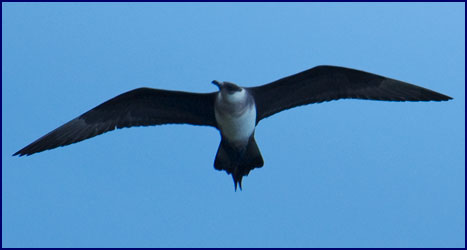
But best of all were the puffins! Lying on our stomachs looking down over the cliff, we could see them far below us, standing or walking along the narrow ledges. Occasionally one would dive into flight, swooping down to the water far below. These comical, squat black and white birds with their wide colorful beaks look like they belong on a cereal box, but they are surprisingly graceful fliers. In fact they spend most of their lives far out to sea, flying or bobbing on the surface of the water like a duck; they only come to land at nesting time.
|
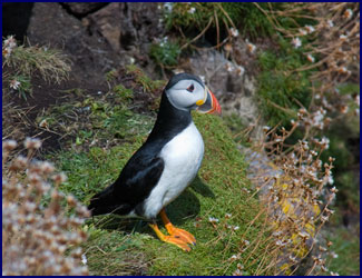
Puffins
|
We had been on the last passenger ferry of the day, so most of the visitors had already moved on and we had the place mostly to ourselves. Wanting a closer look at the puffins, we made our way along the cliff top, trying to avoid gazing over the precipice at the heart-stopping drop, until we found a good viewing spot. Before long, several puffins came out onto a ledge about ten feet from us. We sat for a long time, watching as they waddled along comically before gracefully diving off the ledge into flight.
We followed the shoreline on the path around the island; we couldn�t linger too long, because we had to be back to the beach by three o�clock to catch the ferry. We noticed a large bird flying low over the moor not far from the trail; a quick look at our bird pamphlet told us it was a
skua. I climbed onto a small rock outcropping to try and photograph him, hoping he would come close enough for a good shot. As I looked through my viewfinder he seemed to oblige me, growing larger and larger as he flew straight at me � suddenly I realized he was attacking! I hastily ducked as he dive-bombed me, passing inches from my head. Apparently skuas are quite protective of their nesting grounds! I took a quick shot and then hightailed it out of there, and we caught the last passenger ferry back to the mainland.
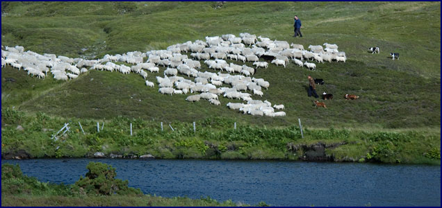
As we left the shore and continued north, the weather remained fine and we enjoyed the scenery along the way. We paused to watch a group of sheep dogs at work; three men and seven border collies were moving a herd of about 100 sheep, probably taking them to be sheared. There was one lone black sheep in the flock. It was really interesting to watch; the dogs love their job, and responding to the subtlest cues from their owners, they efficiently kept the sheep gathered tightly together as they moved them across the countryside.
We crossed through a wide green valley before coming to the northern coast, and ended the day in Durness, at the far northwest corner of the country. It was a lovely area of beautiful shoreline. We explored a church ruin with a cemetery, located right beside a secluded sandy beach. The wind was blowing strongly, and the slanted evening light made everything glow with an almost magical luminance.
|
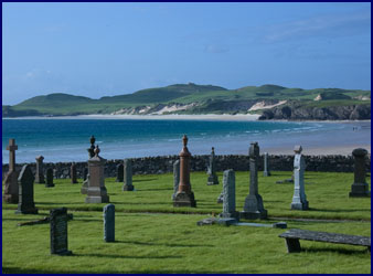
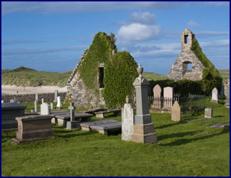
Churchyard by the
beach in Durness.
|
Day 8 - July 28
It is quite interesting on our travels to talk to people from around the world over breakfast. At the Foinaven B&B that morning, we dined with a guy from Belgium who was riding his motorcycle around Scotland - it seemed a great way to enjoy the countryside.
We went to the town of Tongue for area hiking information, but the visitor center turned out to be just a few maps and trinkets in the corner of a wee store. After a glimpse of Castle Varrich from a distance, we headed south again. We followed a small road that headed down the middle of the highlands, with Loch Hope on our right and the great mountain Ben Hope ahead. It seemed that the only hiking paths in the area were for serious climbers who wanted to reach the summit of Ben Hope, definitely out of our league. We were starting to realize that the north end of the country, though beautiful, did not have the same network of hiking trails that had been available when we were further south; we decided to forgo hiking that day and just drive, heading back down to the areas that had more to offer for day hikers.
But that didn�t mean we couldn�t take the scenic route! We headed south by the smallest road we could find, a single lane byway from Loch Hope, and we had the road all to ourselves. We stopped by the Dun Dornaigil Broch where we made the acquaintance of two Highland ponies, but there was not another soul about.
Presently we came to a fork in the road. According to our atlas, the left hand branch, shown as a thin grey line, meandered south where it ultimately joined a larger road, and the right hand fork tapered off to a dotted line before disappearing altogether. But on our roadmap, which was newer, both branches appeared to eventually lead back to a highway. Which way to go? With our penchant for choosing the smallest road available, we of course took the right hand branch.
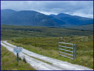
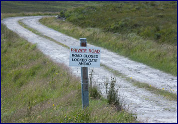
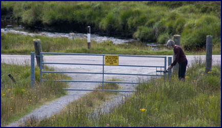
Before long we came to a gate, with a sign that said, �Private Road� in big red letters, and beneath that, �Road Closed - Locked Gate Ahead.� Apparently this message was too subtle for us. After all, the gate was open . . .
Naturally, we went through it. Now we were on a gravel road, the first we had seen in Scotland. Passing places were practically nonexistent; if we met a car we would have to back up for ages. But the only vehicle we saw was the mailman coming out, which we took as an encouraging sign. Our atlas showed that the Governuisgach Lodge was down this road; we expected to encounter the locked gate the sign had warned of there and have to turn around.
Ahead we could see the dark green of a forest in the glen, and a small river ran down before us. We looked across broad valleys with long sweeping slopes and mountains standing regally beyond. Presently we came to a small cluster of stone houses and outbuildings, apparently the lodge. There was a verdant pasture enclosed by a stone wall, with a few sheep grazing. Several cars were parked by the main house, but we saw no people. The wee gravel road continued between the buildings of the lodge, beyond which there was a white gate - but it was sitting open, which we considered an invitation.
Once past the lodge, the road became smaller. We passed two ladies walking with a golden retriever; we thought they were going to ask us what the hell we were doing back there, but we just smiled and waved and kept on going, and the half expected angry shouts of �Stop, who goes there!� did not materialize.
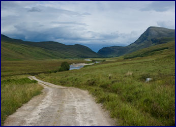
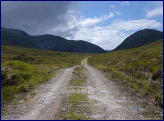
By now the road was just a rough track with grass in the middle; we followed it slowly through the vast empty land. Boggy plains and rocky slopes stretched as far as the eye could see. We crept along, worrying about puncturing a tire. Eventually we came to a beautiful valley with a series of small lochs, and the road began to descend. Our progress was very slow; now the grass was so thick and high in the center of the road that the bottom of our wee rental car was dragging. It was getting harder and harder to avoid the rocks hidden in the grass, and we worried about taking out the oil pan. We were really in the middle of nowhere - it would be a long walk back to civilization!
It seemed like we had been driving this wee road for hours. We wondered if it would actually continue to the main road or just peter out to nothing; we really didn�t want to have to backtrack. It felt like we should be near the end by now. Eventually we passed several small quarries; this heartened us, it was the first clear evidence we had seen that the road did indeed lead somewhere.
We had traveled over ten miles on this tiny track, questioning if we were crazy, and considering how far we might have to walk (and in what direction) should we break down or have a �puncture.� But finally, to our relief, we found that the track did indeed come out to the main road. We rounded the bend and headed down the final slope, where we found . . . a locked gate!
We couldn�t believe it. How do we always get ourselves in these fixes? Perhaps we should have picked up on the fact that the sign saying �road closed, locked gate ahead� was more than just a subtle hint . . .
There was a wee cottage by the road, but the yellow sign on our gate read �The occupants of this cottage do not have keys to the gate.� Guess we weren�t the first ones to follow this route! We backed up until we could find a spot where the road was wide enough to turn around.
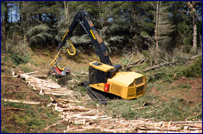
After an extensive backtrack, we returned to the junction in the road, and this time took the left hand fork. We passed through the major foresting area of Dalchork Wood, where we stopped by the roadside and watched a logging operation at work. They used a huge specialized caterpillar that looked sort of dinosaur-like, complete with big grabbing claws and a vicious-looking saw. It would grab a tree, cut it down, run it through a slicer to strip the branches off, cut it into measured lengths and lay them in rows, all in less than a minute, before grabbing the next tree and starting the whole process over again. It was impressive to watch.
We made a quick stop for gas and caffeine, and then drove on, passing the Dornoch Firth on the east coast. We continued south to
Evanton, where we visited the Black Rock Gorge. We walked through a pleasant birch forest along the top of this impossibly narrow, deep gorge, peering down over the edge. It was only about a dozen feet across, but over 120 feet deep to where water rushed through the bottom. We stood on a narrow footbridge and dropped pennies in for good luck.
We were out of the Highlands now, and the area we were traveling through was not particularly scenic. We were a little bummed; we didn�t want the end of our trip to be less spectacular than the beginning. When we thought about what had been our favorite of the areas we had visited so far, the answer was clearly Glen Coe - and we had not spent nearly enough time there. We decided to bypass Glen
Affric, our intended destination, and instead head back to Glen Coe.
We followed the A82 south along Loch Ness. We stopped briefly at dusk at the famous Castle
Urquhart; it is a large rambling ruin on the shore of Loch Ness, steeped in history and myth. We looked for
Nessie, but she was nowhere to be seen.
|
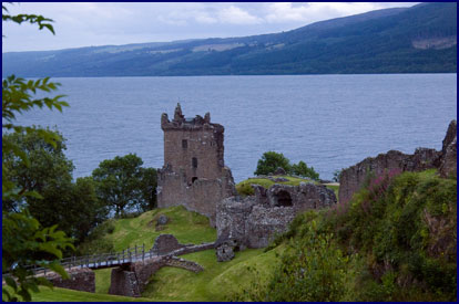
Castle Urquhart, on
Loch Ness.
|
We had been searching for a B&B for some time, but being late in the evening and close to the major tourist centers around Loch Ness, there was not a vacancy to be found. We were getting a bit worried, but we finally found a room at a wee B&B called Strathoich, beside Loch Lochy, where another monster is said to reside. For dinner, we had happy hour in our room; a nice Sauvignon Blanc from Chile, along with bread, pate, cheese, and chutney.
|